Trip Report from ABQ -> FL -> ABQ 2006
Trip Report May 2006
This is the trip report from the 2006 Florida Trip
(in which Prof. Gregory P. Starr ("Dr. Greg") and Dr. David Wilson
rode 4,072 miles
from Albuquerque, NM to Orlando, FL and back!)
NOTE: In this trip report I may make some comments that may
offend people. Please rest assured that those are my opinions only and
are not intended to cause any harm. Thanks!
Executive Summary.
This is a long ride report, and probably not many will read the whole thing
(just my family ;-)
Most of you probably just want a few basic thoughts, then you can look at some
of the pictures (I tried to put explanatory captions on the pictures).
So here are my main thoughts:
- The Buell Ulysses was the perfect bike for a trip like this; it was very
comfortable (no problem with riding position), and the hard cases were wonderful for packing.
The "Uly" was absolutely bulletproof and an overall delight.
- The Avon AV45/46 tires I fitted offered great wear and good feel & traction. I will
fit them again when they're worn (I'll get at least 10K on rear).
UPDATE: Make that 8K...they're still great tires though:-)
- Laminar Lip "windscreen" addition seemed to provide adequate wind protection.
- Never have a deadline...I could have spent another week in the Great Smokies and
the Arkansas Ozarks.
- Finally...avoid the interstates! Secondary roads are much more enjoyable.
But you know that.
The Idea.
It all started when my former student, robotics colleague, and general
all-around good guy Dave Wilson suggested that---since we both had
papers in the 2006 IEEE Robotics & Automation Conference (to be held
in Orlando, FL in mid-May)---that we should undertake a motorcycle
road trip there! Annie (the wife...er, my wife)
said "that sounds like a great idea,"
so we started planning. What a woman! I think I'll keep her!
"Annie, put that rolling pin down!"...
On September 30, 2005 I had purchased the PERFECT bike for a
trip like this: the Buell Ulysses (with hard luggage). The only
modifications I've made to the "Uly" are (1) the Laminar Lip---a
windscreen addition that deflects some wind off one's torso, and (2)
Buell "Traction" grips. Other than that the Uly is stock. It's
a very "friendly" bike to ride, and the combination of relaxed V-Twin
power, lots of suspension travel, and amazingly sharp handling make it
a great bike for an old geezer like me. I can go just as fast on most
twisty roads on the Uly as on my Aprilia Mille, for example. And in
much more comfort. What a great bike; only wish the fan weren't quite
so noisy...
Oh yeah, one final thing. When Buell came out with a "GPS" option (hey,
those are my initials!)
for the Ulysses I declined to spend $600 and bought the Garmin Quest myself for
half that. With a RAM mount it was the perfect setup. This trip was the first
opportunity to really put the GPS to a test. It turned out to be invaluable...
The People.
"Dr. Greg." I'm a 58-year old Professor of Mechanical Engineering
at The University of New Mexico in Albuquerque, NM. I've been riding
motorcycles since there were only "bikes" (not dirt bikes, or touring
bikes, or sportbikes, just "bikes"). Owned just about everything, and
still own a 1984 Yamaha RZ350, 1992 Ducati 900SS, 2000 Kawasaki KLX300R,
2000 Aprilia Mille RSV, and 2006 Buell Ulysses XB12X. Over the years
I've adopted the nickname of "Dr. Greg"---I tend to refer to myself
that way in this report. By the way, I am in fact a
doctor: Ph.D. in Mechanical Engineering from Stanford University,
1978. So I really am a doctor...just not that kind.
Moved to Albuquerque in January 1977 for the UNM job, and will probably
stay here forever. I have four boys: Paul (27), Keith (25), Mark (20), and
Jeff (13). Obviously I can never retire!
Dr. David Wilson. Although he prefers "David" I can't get over calling
him "Dave" (sorry David!). DW came to New Mexico in 1993 as a Ph.D. student
of mine---he had a great background at Washington State University,
Rockwell Int'l., Univ. of Washington, and Boeing. We finally agreed on
a research topic for him, and he did some GREAT work in the area
of flexible robots. He currently is a staff member at Sandia National
Laboratories in Albuquerque, NM. When he came to me last fall and said
"I'm interested in getting a motorcycle" I thought...ALL RIGHT!! We found
a Yamaha FZ6 for him, and that's what he crossed the country on (hey, he
didn't know any better, and had a great time!) You don't need a Gold Wing
to have a good experience on a long trip, that's for sure. By the way,
Dave is 6'-5" but he claims he has plenty of room on the little FZ6.
And---he's a doctor, too!
Day 1 (Friday, May 12): Albuquerque, NM to Jacksboro, TX...556 miles
I left Albuquerque, NM at 6:40 a.m. on Friday, May 12, after having a
bowl of Cheerios and a hug from Annie. Figure 1 shows me---helmet in
hand---getting ready to ride out the driveway (yikes, is that
gray hair?). It was COLD...
the last time for several days I'd be cold, by the way!
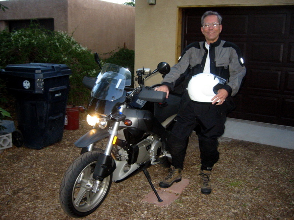
Figure 1. Leaving my driveway in Albuquerque at 6:40 a.m. on May 12.
It is COLD at 5,000 feet in early May in New Mexico!
Rode east on I-40 to meet
Dave at
Sedillo exit (about 20 miles). We met at a big open area where they're building a new travel center
or something. Figure 2 shows a picture of "Dr. Greg"
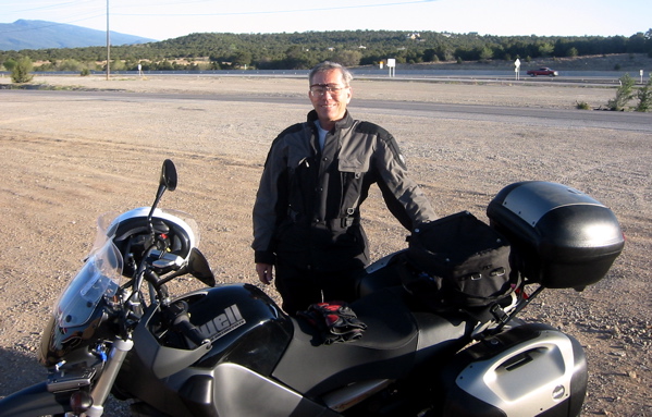
Figure 2. Sedillo, NM on May 12. This is where
I met my buddy Dave (see Figure 3 below).

Figure 3. My good buddy (and good rider)
David Wilson and his new Yamaha FZ6, at
our meeting point at Sedillo, NM (near I-40).
We rode the 100 miles to Santa Rosa without stopping and had breakfast
at the Denny's there. Also refueled at a gas station where the pump was very slow.
Left
I-40 at that point and took US 84 down to
Fort Sumner, where we stopped briefly at the Billy
the Kid Museum, but didn't really go in. Couldn't resist getting a picture of "Dr. Greg"
and a beautiful old 1946 Ford (the owner drove it away a few minutes later and it
definitely had a well-tuned flathead V8 in it!) Hey, 1946...that's the year before I was born!
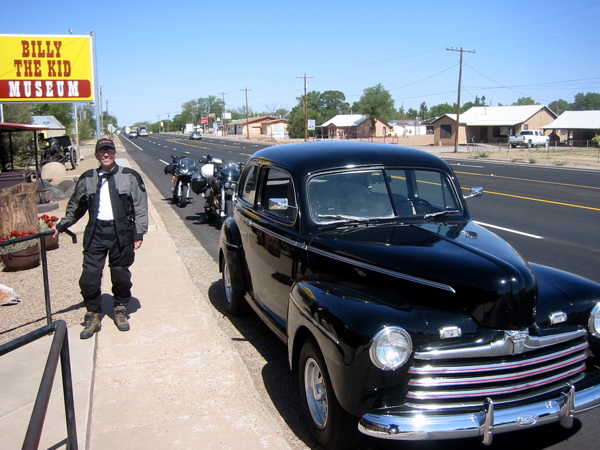
Figure 4. Dr. Greg outside the Bill the Kid
Museum at Ft. Sumner, NM; along with beautiful
old 1946 Ford (it sounded good, too!)
Couldn't resist getting a picture with the "Billy the Kid" stagecoach (Figure 5).
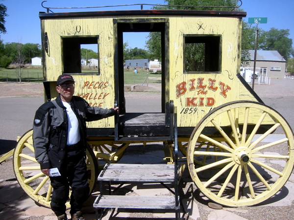
Figure 5. Dr. Greg and stagecoach, at Ft. Sumner, NM.
We continued east on US 84 to Clovis, NM where we refueled. There were lots of "Save
Cannon AFB" signs around; looks like the AFB is still going. Base closure hits these
small towns pretty hard...
Continued
east to Texico, NM; this was close to the Texas border. Our first state line!
Wanted to stop at the "mule monument" at
Muleshoe, TX, but couldn't find it (didn't try too hard). Went on and stopped at another
town about 20 miles further along (Sudan? Amherst?).
The country began getting a little greener the farther
east we went. Had lunch (and refueled) at a Subway just east of Lubbock.
The GPS was a big help getting through (around) Lubbock; the first of many situations
like that.
Continued east
from Lubbock on US 82 which led us through numerous small towns;
Crosbyton, Guthrie, Benjamin, Red Springs, Olney...
pretty fun riding (although straight). We stopped at the numerous "picnic areas" that
abound in this part of Texas...Figure 6 shows Dave Wilson and the bikes taking a break.
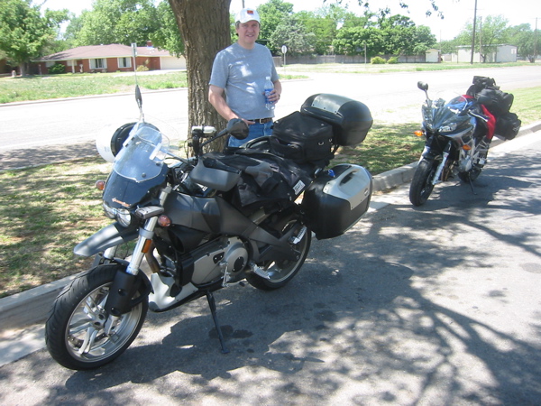
Figure 6. Dave Wilson and our bikes, somewhere in west Texas...
Time for a rest stop! It was fairly warm, though not bad.
We crossed the Brazos River near Seymour, TX, and dropped into a wide (5 miles) and
unexpectedly pretty river valley. The countryside was pretty flat, then all of a
sudden we saw a "twisty road sign" and we started dropping into the Brazos valley.
Crossed the river at the bottom, then a nice little climb back up. Pretty cool!
The winds were generally good; tailwinds through
New Mexico, and sidewinds through Texas (calming late in the day). We wanted to make it a
fairly long day since the weather was good, and we ended up getting
to within about 70 miles of Fort Worth;
staying at a fairly seedy motel at Jacksboro, TX (see Figure 7). Ironically when I was
planning the trip on the GPS I thought we just might make it far as Jacksboro, so I checked
for motels...there were three. The first two were really unencouraging, so I hoped
the third one really existed and was a little better---and it was.

Figure 7. Here's the "Jacksboro Inn;" looks better than it was, although we had
more trouble with "white trash" kids than the Mexican construction crew.
We were able to park the bikes right
outside the room; Dave claims he is a light sleeper so we hope for the best. There are a
bunch of "Mexican" construction workers who are probably spending the evening at a bar;
here's hoping
they don't get too noisy around 2:00 a.m. when they return! I had "broiled catfish" at
the nearby restaurant; quite good. We always tried to stay within walking distance of
a restaurant.
The restaurant seemed to be a local gathering point,
and there were some families (and a pretty hot "soccer mom"---with a great figure---
but I still love YOU Annie) with
Little League players that came in to celebrate. Pretty cool. All in all a very good first
day.
And it was my SECOND LONGEST day of all time: 556 miles!! I know, not that far for
some of you guys, but a long day for me (my all time record is 637 miles in 1970 on my
new 1969 Honda CB750 4-cylinder back in Cali). A great first day! Orlando here we come...
Day 2 (Saturday, May 13): Jacksboro, TX to Jackson, MS...497 miles
At the "Jacksboro Inn" there were no problems of any kind from the construction
crew; they were long gone by the time we awoke.
That's gotta be a hard life; those guys
have to take some relief when and where they can. They've got my vote!

Figure 8. Sunrise at the "Jacksboro Inn"...not a bad place after all.
However...there were some rowdy "white trash kids" at about 4:00 a.m. who were yelling and
screaming a bit. We got back to sleep before being awakened at 5:50 by my iPod alarm.
We had breakfast (breakfast burrito for me, being a
confirmed New Mexican) at the same restaurant in Jacksboro (it definitely was
a local gathering point) and left around 7:45 a.m. in very nice weather. TX 199 led
through very pretty ranching country; the road was 2- and 4-lane secondary, but in good
shape. As we neared Ft. Worth the traffic increased, and the roads became limited-access.
Going through Ft. Worth-Dallas was very stressful;
the sun was in my eyes and it was quite
difficult to interpret the GPS. Had to stop and ponder a couple times, but made it through
all right. Here the GPS was a lifesaver; I would've had to stop and check the map
repeatedly. And this was Saturday morning; I can only imagine if it had been a weekday.
After getting through the "Dallas" part of Ft. Worth/Dallas I
actually saw "Texas Stadium" (home of the Dallas Cowboys). Whoopee (I'm not an NFL fan...
however, I am a college football fan...I attended USC and Stanford and root for them).
After leaving Dallas the country got greener as we approached the "Piney Woods" of East
Texas.

Figure 9. We enter the "Piney Woods" of Texas (rest area plaque).
We headed east on I-20 towards Shreveport, LA. The country
got greener and greener as we headed east, and I stopped en route
to take a picture of the
exit sign for "Starrville!" (as you recall my name is Greg Starr) All right!

Figure 10. Hey, a town named for "Dr. Greg" Starr! All right!
We arrived at Shreveport, LA, home of "Fast
Freddie" Spencer, the famous 3-time world roadracing champion. Freddie won BOTH
the 250cc and 500cc (like MotoGP now) titles IN THE SAME YEAR back in 1985.
Nobody has even thought about doing that since.
I had breakfast with
Freddie and drove him to the Santa Fe, NM airport in 1998 when he was guest speaker at
a rally I organized. Nice guy, and still, uh, pretty fast! Even if he did ride for
Honda...see, Figure 11 proves it!! Dr. Greg and Fast Freddie.

Figure 11. "Dr. Greg" and "Fast Freddie" Spencer in Santa Fe, NM in 1998.
Hmmm, Dr. Greg's hair seems a little darker "back in the day"...
We tended to stop at rest
areas occasionally to well, rest, and look around, etc. Breaks up the trip, and we have
time to do that. Figure 12 shows me, well, stopping at a rest stop somewhere in east Texas.
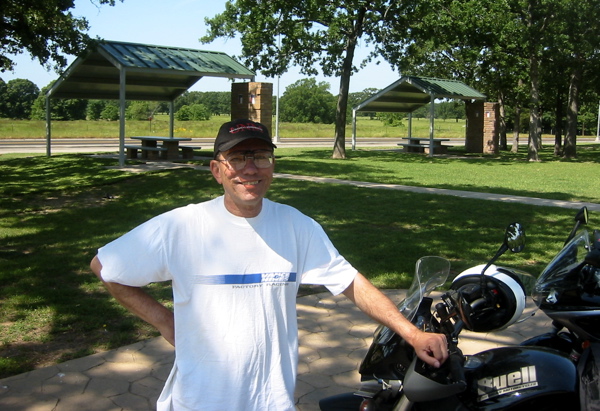
Figure 12. Taking another break; somewhere in east Texas. Look at
all the green grass...amazing! (speaking as a New Mexican here).
The Louisiana "welcome center" was pretty nice; took a few pictures
there; you can see one in Figure 13 below. Pretty green compared to what I'm used to...
New Mexico is in the throes of a severe drought.
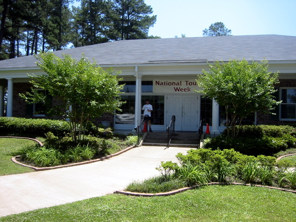
Figure 13. Louisiana "welcome center"...it's National Tourism Week!
We became very good at finding whatever "shade" existed wherever we stopped. In New
Mexico the sunlight is very intense (high altitude, 5000 ft and higher)
and sunshine/shade is a big difference.
I expected that in the more "humid" regions there wouldn't be much difference...WRONG!!
We always tried to find the SHADE!! Figure 14 shows our little shade patch at the
Louisiana Welcome Center. Very nice!

Figure 14. Little shade patches like this---Louisiana Welcome Center---are sure nice!
We arrived at the Mississippi River at about 6:00 p.m. at Vicksburg, MS.
There was a very nice Mississippi
"Welcome center" where I also took several pictures. Figure 15 shows the Mississippi.

Figure 15. Vicksburg, Mississippi. Beautiful area and nice weather!
Boy, this river is a LOT bigger than the Rio Grande...
The last 44 miles into Jackson, MS
were very pretty; corridors of I-20 were lined with beautiful big trees. Nothing like New
Mexico, that's for sure! Found a room at the "Super 8" motel and had dinner at the
nextdoor Chinese
restaurant. Forecast for tomorrow is for 40% chance of rain...thundershowers. We'll see.
Oh yeah, there was a big beautiful full moon rising just after sunset. I took a picture
of it but I really needed a telephoto lens. Mileage for the day was 497 miles; not bad!
Day 3 (Sunday, May 14): Jackson, MS to Panama City Beach, FL...343 miles
Awoke at Jackson, Mississippi to a forecast of showers. And it was true (see Figure 16).
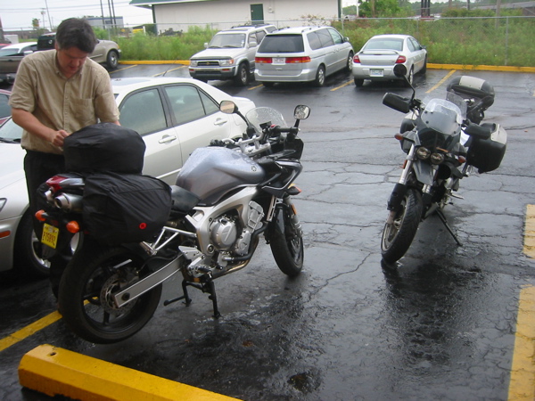
Figure 16. Morning showers in Jackson, Mississippi. Dave Wilson
packing up the FZ6. Showers cleared pretty fast.
We had a "continental breakfast" at the motel breakfast buffet, and packed the bikes in
the rain (a light rain, however). Riding south on US 49
out of Jackson toward Hattiesburg, we went
in and out of showers. Actually the riding was pretty nice. I stopped to take a break
just before we turned onto I-59 (for just a few miles) and Dave suggested we go into the
nearby "Waffle House" to have a bite to eat. I got a waffle (naturally) and it was indeed
very good. The waitress was really good; she struck me as someone to whom life hadn't been
too kind but was an eternal optimist.
I could see myself just wanting to marry her and take her away to a better life
(but I STILL love YOU, Annie) Funny how people just grab you sometimes...OK, ok I'll get
off my white horse now! ;-)
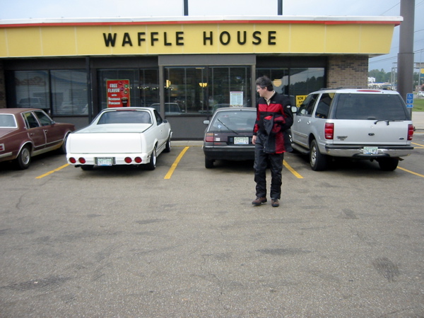
Figure 17. Waffle House near Hattiesburg, MS. Lovely waitress
(hope you catch a break, sweetheart) and a darned good waffle!
The country around there (between Jackson and Hattiesburg) was just beautiful: green grass,
big trees, lots of ranches/farms, lots of tractors (!)...I could easily see living there.

Figure 16. Dr. Greg and some tractors. Say, this area is pretty nice!!
And I never thought I'd say that about Mississippi (the only state lower than New Mexico
in many statistics).
Anyway, we headed southeast on US 98 towards
Mobile, and got there uneventfully. The showers had cleared up by then and the weather was
pretty nice. Humid, but not a bother.
My colleague Joel Beer (his license plate reads "DR BEER")
had mentioned the USS Alabama on display somewhere around Mobile,
and indeed we found it! We took the tour (Dave paid...thanks!) and it was absolutely
amazing. We walked all through the ship...down to the engine room (lots of great pictures),
through the crew quarters, up to nearly the top deck (that ship is TALL), etc.

Figure 17. Dr. Greg and the 16-inch guns on the USS Alabama.
Trying to
imagine the crew working hard in those tight spaces in the humidity of the south Pacific
in 1943 while fighting the "Japs" really made me think. Picture yourself in 1943 down
in the engine room of Figure 18 while under a Kamikaze attack. "Greatest generation" indeed.
BTW, the "lower" rooms were almost completely dark; my flash camera produced pictures that
revealed what was down there. While actually down in the ship it was difficult to see
very much at all. These pictures are amazing (to me, anyway).
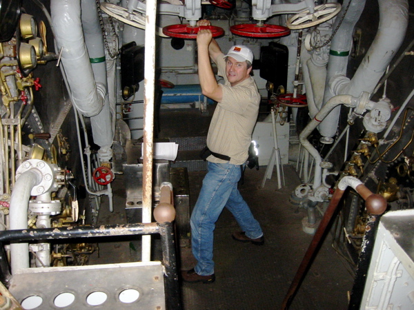
Figure 18. David Wilson manning the engine room on the USS Alabama!
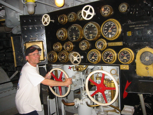
Figure 19. Dr. Greg tries his hand at handling the USS Alabama...
There were even two "Starrs" that
served on the Alabama...relatives, perhaps?

Figure 20. Dr. Greg's long-lost "Starr" relatives that served on the "Alabama".
The Mitsubishi fighter planes were a threat in 1943; now we buy cars from
them...probably better now! A nice lady at the visitor center let us stow some of our gear
there so we weren't worried about it. Anyway, we probably spent two hours there before
continuing on across the "tip" of Alabama and into Florida.
Well, the Florida "welcome
center" was nice, but (so far) Florida pretty much sucks! Lots of traffic, lots of big
condos, no motels, did I say traffic?
Back at the "welcome center" I had thought about
getting to "Panama City Beach" for the night, but decided it was too far (I thought
we lost an hour to the time zone change; apparently not). We rode on US 98 through a lot
of "development" but very few motels. My low fuel warning light came on, and still
no gas
station or motel. Finally I used the GPS to locate a motel; it was down along the beach.
Turns out that's where things were. The motel we found wasn't really our style
(a little too fancy), but the desk clerk
advised us to continue a few more miles east along the Gulf Coast; there was more stuff
that way. Sure enough, we found a gas station (plan to fill up tomorrow morning), and
(with some difficulty) a motel (the "Palmetto"). The "motel office" was a trailer, but the
rooms were all right.
We got a room with direct visibility to
the bikes (always nice) and there was a great steak/seafood restaurant next door! So we
had an excellent dinner (and a couple beers) at which we had the "Scamp" fish dish (on the
waiter's advice). It was really good! Wish I had saved my leftover baked potato, since
there's nothing for breakfast (except coffee with sugar!).
The forecast for the morrow is showers and rain...we'll see.
Forgot to reset the GPS yesterday morning, but (by subtraction) mileage was 343 miles; not bad
considering the traffic, etc.
Day 4 (Monday, May 15): Panama City Beach, FL to Tallahassee, FL...159 miles
Spent a very restful night at Panama City Beach, Florida. Probably not the case if it
were, say, Spring Break!
Dave went out this morning to walk along the beach (I'm not interested---seen one beach,
seen 'em all---I'm typing this trip log entry instead),
but I'll refuel as soon as we leave, then look for a restaurant (Waffle House?)
Even though the motel
didn't have a breakfast buffet---I said that, didn't I---they DID have an in-room coffeemaker which I used.
Dave doesn't drink coffee, so like I said he went off on a stroll
down to the beach while I composed
the previous day's trip report (too tired last night). The weather forecast was for rain
and showers all through Florida, but I looked out the window and it looked pretty sunny
(see Figure 21). "Don't need a weatherman to know which way the wind blows..."
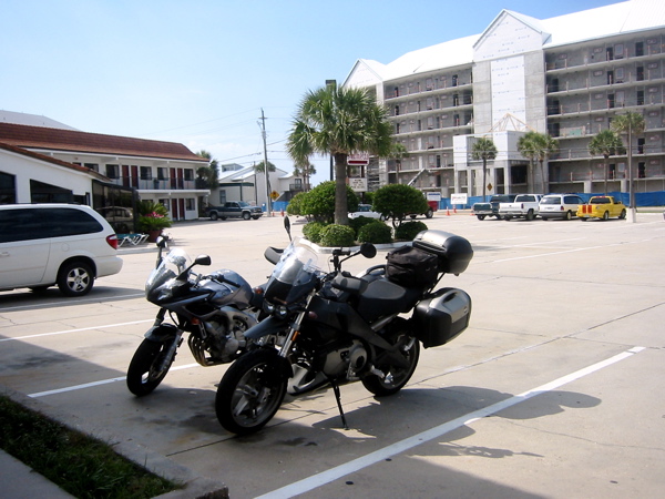
Figure 21. Our bikes outside the "Palmetto" motel in Panama City Beach, FL;
Weather looks pretty good to me (rain in forecast). New hotel under
construction across the
street...too expensive for Dr. Greg!
We took our time getting underway, since we don't have that much more distance to cover.
Finally I got my gear pretty much packed up and decided to use the GPS to find somewhere to
eat breakfast. Since the "Waffle House" waffle kept us going for so long, I hoped to find
a Waffle House...and I did! I asked the GPS to "find it" and it led us around a couple
corners and there it was! Science is wonderful! I couldn't resist having the "full meal
deal" breakfast; two eggs, sausage, hash browns, toast, AND a waffle! And I finished it!
Probably a two-meal day today... I used MapSource to plan a "new" route from Panama City
Beach to Orlando (via several small towns on the "Emerald Coast") which we'll use over the
next two days. The beach had very "white" sand, and it was quite pretty (Figure 22.)

Figure 22. The beaches along Florida's "Emerald Coast" are quite pretty; also the
water is sure a lot warmer than in southern California (my misspent youth).
We left the Waffle House and headed east on US 98. While going through
St. Andrews the GPS said "turn right" so I did, and took a route down along the coast.
There was a sign "monument 1000 ft. ahead" so I turned into a small parking area at the
monument. It was a minor Civil War monument (see Figure 22).

Figure 22. A Civil War "skirmish" along Florida's Emerald Coast.
The weather was gorgeous (rain showers?) We
rode along US 98 uneventfully through several towns along the coast. Figure 23 shows
Dr. Greg along the water. We wanted to walk out along a pier but it was clearly marked
"U STAY OUT" so we abided (motorcyclists are good people!)
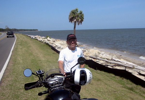
Figure 23. Dr. Greg and the Ulysses along the Emerald Coast of Florida. See any rain?
As we rounded the "bulge" of the coast (Apalachicola area),
the country was pretty rural; I began getting concerned about finding a motel, so I stopped
and consulted the GPS. At that point we were only about twenty miles from Tallahassee,
which I figured would have ample lodging. Sure enough, the GPS found many motels in
the Tallahassee area, one of the closest being the "Days Inn" (which is about our style).
So I let the "oracle" (GPS) lead us to the Days Inn, and we went right to it. I NEVER
would have found it by myself. GPS is really useful.
So I checked in, and we were able to park
the bikes right outside the room, which is always nice.
Turns out there was a Mexican
restaurant within walking distance, and they had 2-for-1 on Dos Equis beer! What a deal!
We had a good dinner, and I kept my leftovers for breakfast tomorrow (we have a microwave
in the room). This motel does have a breakfast buffet, but a nice plate of chile rellenos,
beans, and rice sounds like just the thing for breakfast! I'll probably plan a new GPS
route from Talahassee to Orlando (to the Hilton near "Disney World"
where our robot conference is being held)
tonight to optimize our approach. The day's
riding total was 159.4 miles, with "moving average" of 50.2 mph (less than our 65 mph
usual. Damn traffic! ;-)
By the way, just about every piece of beachfront property (apartment, condo, whatever)
along the "Emerald Coast" of Florida is FOR SALE! Not that I'd want to live there...
Day 5 (Tuesday, May 16): Tallahassee, FL to Orlando, FL...247 miles
Whew, what a day! Actually, what a night also! Just after I dozed off
last night some idiot started honking his horn. At first it was a short beep like when
you lock the car with a remote control. But it woke me up. Then just after I fell asleep
again he honked again, which again awoke me. Back to sleep...another honk, longer this
time, so it was done by a human. Another, and another...the last time I said to myself
"I'm going to call the office on the next honk," but it was the last. Then I had a hard
time getting to sleep...ARRGGHH! Stupid idiot!! In the morning it was somewhat cloudy,
but no rain...looked like it would be a pretty nice day. My iPod alarm went off at 5:50 a.m.
and I got up around 6:00 a.m. Did my morning preparations and wandered down to the
breakfast buffet to get a cup of coffee. I got it out of the wrong thermos and it wasn't
very warm, but I warmed it in our room microwave.
The birds were just singing like crazy
here; kind of picked up my spirit to hear them. Figure 23 shows the trees from where
they were singing. Sure don't hear birds like these in New Mexico!

Figure 23. The birds in these trees (Tallahassee, FL) were just singing like crazy!
Picked up my spirit after a lousy night of stupid horn-honking. :-(
Turned on CNN to hear the reaction from
President Bush's address on immigration. Dave and I both went down to the buffet and this
time I got hot coffee (correct thermos this time). I had a bowl of cereal and ate some of
the leftover beans and rice (couldn't face the chile relleno in the morning after all).
We finally
got underway about 8:10 a.m. Headed southeast on route 27 almost all day; alternating
between lots of traffic lights and wide open stretches at 70 mph. The stoplights are pretty
fatiguing, but they do break up the riding. About 11:00 a.m. we stopped at the "Boondocks
Grill" in Bronson, FL to have a REAL breakfast (which we did).

Figure 22. The "Boondocks Grill" on US 27 in Bronson, FL served a darn good breakfast.
There was a table of three
guys in "The Boondocks" who were classic "poor white trash" types...one thin guy
covered with tattoos and
long scraggly blonde hair, another guy in army fatigues, and a third whom I forget. They
just had that look...probably nice guys, but just had the look.
We left the "Boondocks" and headed through
more stoplights and more development (fancy condos, etc.) and got closer to the Hilton.
Around 3:00 we actually arrived! WE MADE IT!! The GPS led us RIGHT THERE...what an
amazing device. The bellperson took our picture (Figure 23)
and said we could park the bikes right on
the sidewalk out front! Wow, that's amazing!
Oh yeah, it rained most of the day. Dreary weather. Welcome to Orlando...
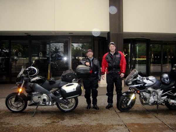
Figure 22. We MADE IT!! Dr. Greg & David Wilson in front of the Hilton at
Walt Disney World (near Orlando, FL). Rained most of the day...
We registered at the hotel; my room is on
the 9th floor. I took the GPS off (put it in my coat pocket), unhooked the bags and Dave
and I carried everything in and up the elevator, then on into my room (he went to his
room). I saw that I had a missed call from Dan Z (Master's student of mine; he's
presenting our paper)
so I called him and he was still driving
from the airport to the hotel. I took a shower, then Dave and I met down at the elevator
and registered for the conference. We then stopped by the bar and had a
couple beers to celebrate our arrival, then
Dan joined us later. We all agreed to meet about 7:15 p.m. and go out for dinner. Just
before going down I though I'd check the day's mileage on the GPS, but I couldn't find it
anywhere!! I was devastated!! How could I lose it?!?! I went down the bellman and asked
about security cameras, etc. Then I had an insight: I put it in my jacket pocket! I ran
back to the room, and it was there! I called Annie to tell her (I had called her when I
thought I had lost it), then went down to join the guys, but...
...a huge security guard stopped me. I explained... "I found
the missing GPS. I had misplaced it, and...um, uh...it was all MY fault." This guy
was Buford Pusser (we'll see him again) reincarnate.
Then he said "you can't park your bikes
there." He showed us around back where he wanted us to park them; some way in between the
reserved car areas...I couldn't really understand. By way of consolation he gave us keys
to the "executive suite" area...free breakfast bar and the like. I would have loved to take
his picture, but I'm not sure he would've appreciated that.
So we went back in and told the bellman
that we needed our keys back so we could move the bikes.
The bellman met us out front, gave us the keys,
and said "you guys don't need to park back there, park out front here in these reserved
spaces." We felt like pawns in the power struggle between the security guard and the
bellman! But we parked out front.
We got a dinner recommendation for the "Outback
Restaurant" (not the steakhouse) from the bellman (walking distance) and started
out the front door when we
spotted the huge security guard! Not wanting to get yelled at for not obeying his parking
"suggestion" we found a side door and walked the not insignificant distance to the
restaurant (me in my moccasins getting my feet wet yet again!...and fraying my cuff because
of my stupid short leg!). The restaurant was good but extremely expensive ($122 dinner
bill for just we three!). Hopefully I'll get reimbursed somewhat. Sigh. Should have had a
hamburger or something... Anyway, we walked back to the hotel and Dan and I checked out
the "executive suite" area...not that impressive, but we'll go there for breakfast
tomorrow morning. I'm sure glad this day is over. Oh yeah, mileage was 246.5 miles;
moving average speed 53.9 mph (all the stoplights). So the TOTAL MILEAGE for the outbound
leg of the trip was 1801 miles.
Day 6 (Wednesday, May 17): At "Robot Conference" all day...0 miles
DID NOT set an alarm this morning, and awoke about
7:30 a.m. Well, no chance to make the 8:30 a.m. technical
session, so shoot for the 10:30 a.m.
session when Dan would present. I decided to do a "room wash" of my three dirty T-shirts
in the bathroom lavatory just using hand soap; better than nothing, and much cheaper than
letting the hotel wash them (price?) That worked out OK; then I ironed them with the room
iron and board (Figure 23).
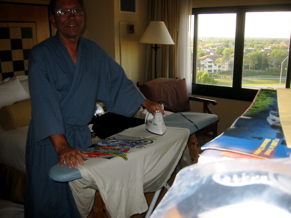
Figure 23. Dr. Greg trying to remember how to use an iron...help, Annie!
The iron ran out of water and shut itself off halfway through; it took me
quite a while to figure out how to add water! But I finally got it. I ironed all three
shirts and found a way to hang them against the room windows; they actually seem to be
drying somewhat.
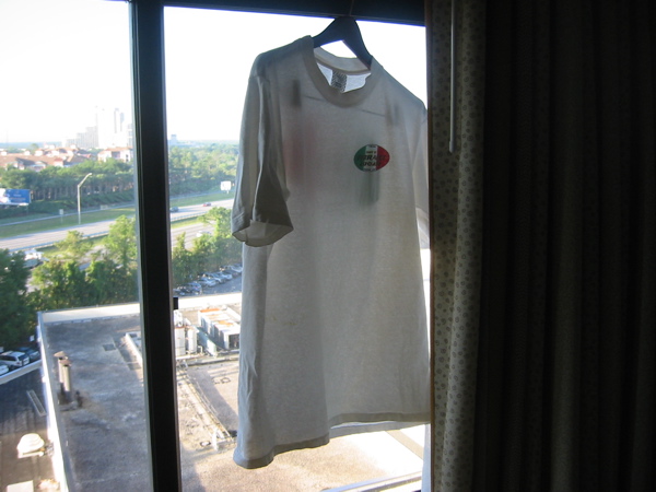
Figure 24. My treasured "Fast by Ferracci" Ducati T-shirt drying
in the hotel window. Room-washing actually worked pretty well!
Around 9:00 I realized I was hurting a little---aha, I hadn't taken my morning pain
medication (I've had so many fractures from bicycle/motorcycle crashes...me and
Rush Limbaugh)
---so I did, then I went down to the "Executive Buffet" area and ran into Dan
Cox who used to be at UT Austin. He is now at the University of North Florida, and we had a
little chat. I had mostly fruit (a welcome relief from overeating) then went down to the
first floor, where I saw Dave Wilson at a breakfast alcove.
Then we all split up again and I put on
my swimming trunks, my "Hawaiian" shirt, and headed for the spa (which I had found
earlier).
It was a two-level spa that was both (1) deserted, and (2) HOT!! I turned on
the jets at first, but their main effect was to fill my pockets with air so vigorously
that they turned inside out and ballooned up to my armpits. When the jets turned off I didn't
restart them. I relaxed in the upper spa for a while, then got out and sat in the shade,
then went in the pool, then back in the spa, etc. Very relaxing!
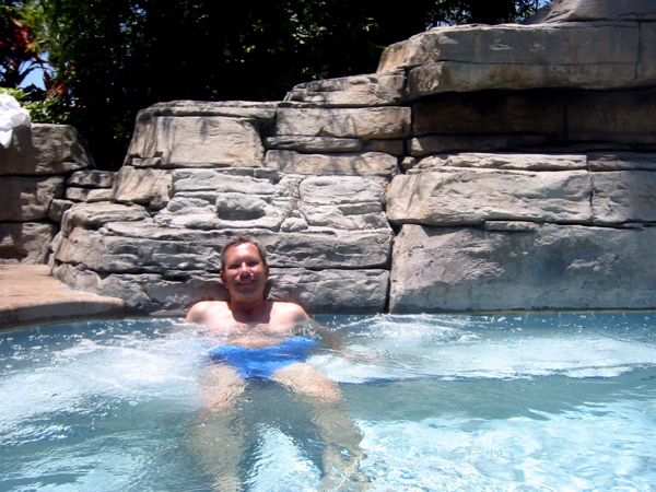
Figure 25. Dr. Greg working hard at the robot conference!
Came back to the room
about 2:00 and started typing this entry. The first afternoon session starts at 2:45, and
I'll probably go to it, plus some of the second afternoon session. The banquet is tonight
at 7:00, and Dave and I will likely go together. My spirit has improved somewhat from
yesterday...in general the sooner we get out of Florida the better.
Just got back from
the "late afternoon" session, where I also talked to Bill Townsend (Barrett Technologies)
Turns out that Bill took an 18,000-mile motorcycle trip all through the USA and
Mexico around 1980 or so!! Unbelievable!! And to think I thought riding 1,800 miles from
Albuquerque to Orlando was a big deal...I'll certainly view Bill in a different light from
now on! Amazing!
Dave's talk is tomorrow---which I'll
attend---then we're outta here! By the way, my T-shirts have dried very nicely---as has
everything that was wet. Washing them in the lavatory with hand soap was a very good idea,
they smell fresh and are nice and dry. The next 2,300 miles (or so) looks quite do-able! So I
called home after the banquet tonight (about 10:30 EDT; 8:30 MDT) and I got
13-year old son Jeff (in the
car) who said "I think I broke my foot." Oh, great. I'll call back in ten minutes and
get the full story.
Day 7 (Thursday, May 18): Orlando, FL to Gainesville, FL...115 miles
When I got up this morning (about 7:00 a.m.) I wasn't sure if I had
called Annie last night. Then I looked at the previous day's log and I saw that I had
indeed called and found out that Jeff may have broken his foot. Serves him right for
being on the neighbors' trampoline. Get this: we dislike these neighbors because they let
kids play unsupervised on the trampoline, but all of our kids ride motorcycles! I guess
safety is in the mind's eye. I'll take motorcycles any day.
This morning I'm having a fairly leisurely morning packing everything
up, etc. Probably wear my "good" pants on top of the shorts I wear riding. Since checkout
time is 11:00 a.m. I'll have to be fairly creative to work out the riding/clothes thing.
Planned a new GPS route based on the advice of the guy we met at the gas station Tuesday.
Since we were pressed for time he advised us to take GA 60, TN 68, etc.
It's been really nice to have a "rest" here at the Hilton...wash out the T-shirts, get to
repack everything, etc. Dave's talk this afternoon is from 3:30-3:45; hopefully we can
leave right after his talk (and not stay for the end of the session at 4:15).
Figure 25. Getting ready to leave the Hilton at Orlando; time is 4:30 p.m.
It may be
a challenge to get out of Florida today...and yes, indeed it was a challenge! Sigh. We
left the Hilton exactly at 4:30 p.m. and faced a 50-mile ride on secondary roads through
many small towns and MANY traffic lights (we're avoiding the toll roads, which suck
on a motorcycle since I keep my wallet in the top case and wear gloves) to get to I-75 at
Ocala. It took us TWO HOURS to get to I-75...exactly at 6:30 p.m. So I rode at about
75-78 mph on I-75 for a while to get SOME distance covered. Weather was pretty nice. We
stopped for gas after 20-30 miles, and at that point Gainesville, FL was about 20 miles
away. It was almost 7:00, and I thought we could get near Lake City, FL in about an hour,
so I departed with that intent. However, the GPS (on which I rely TOTALLY) got hung up
and needed to be reset. I had to stop (on the shoulder of I-75 with semis zooming past
4 feet away) and get out the manual to reset it (simultaneously depress PWR and IN). It
reset just fine, but the delay made me rethink our motel area...
I decided to go for the
"Quality Inn" near Gainesville; only about 10 miles away. I set the GPS to lead me to it,
and resumed riding. We did find the motel, and as I was riding up to the check-in area I
tried to "thread the needle" and ride between a car and the curb. Well, my left side case
hit the car and launched the Ulysses and me off into a flower bed. DAMN! The only casualty
was the right front turn signal, which was broken off. I'll clip the wire tomorrow morning
and put it in the top case; fix it when I get home. STUPID, STUPID!!

Figure 26. I crashed (well, tip-over) trying to "thread the needle" between car
and curb (gotta remember the side cases!). Stupid, but no real harm done.
Our mileage for the day was 115 miles; moving average only 49.5 mph. Total time 3:00.
I went to bed about 10:30 but could not get to sleep. My heart was just pounding in my
chest...a degree of reaction from my "crash", I'm sure. I called Annie twice; the last
at about midnight (EDT). She suggested I listen to
the meditation tapes, so I did the "body scan" and slept through much of it. I awoke to
the "sitting meditation" tape (the next one after the body scan) so I had obviously slept.
I put the iPod away about 1:30 a.m. and feel asleep just fine. Whew, what a night!
Tomorrow has got to be better...
Day 8 (Friday, May 19): Gainesville, FL to Gainesville, GA...381 miles
The iPod alarm went off at 5:50 a.m., but I didn't get up until 6:30.
So that gave me about five hours of sleep; I need at least seven.
Oh, well. Dave and I went down to the
breakfast buffet and had our bowl of cold cereal (I also had a toasted bagel w/cream
cheese). I clipped the wires holding the right front turn signal on and put it in the top
case for repair after we get home. We left Gainesville, FL about 8:15 a.m. and started up
I-75 towards Macon, GA. I rejoiced when we crossed the state line and were out of Florida.
For me, Florida pretty much sucked. Also had a nice picture taken at the GA "Welcome
Center" with a cutout of Scarlett O'Hara (note the Mert Lawwill T-shirt!)

Figure 27. Dr. Greg and Scarlett O'Hara (but I still love you Annie)
So we continued up I-75 at around 75 mph, just
trying to cover ground. For most of you 75 mph is snoozing, but I've lost my desire to
ride fast on slab...first sign of old age, I guess!
It was about 260 miles to Macon, GA, where we turned off onto
secondary roads (AT LAST!) But in the meantime
I noticed a Wal-Mart at Valdosta, GA, so we backtracked to it and I went
in to get some Mobil-1 15W-50 oil (the Uly was a little low) and shoe waterproofing
(my vaunted "Gore-Tex" boots left my feet a little
damp, so time to spray them). No, not THAT Gore...
I found both fairly quickly, but at the checkout the shoe waterproofing
didn't show up in the computer so the cashier had to walk---er, "saunter"---back to
the shoe department---which was at the far corner of the store---to see
what the problem was. After a LONG delay (I'm not a big fan of Wal-Mart)
she returned with a "packaged" form of the
product; someone had separated the components. So it was my privilege to also purchase
a bottle of "human scent stopper"...seems the package was for hunters. Well, hell...some
"human scent stopper" might be just the thing when I get home to Annie!
I added about a pint of oil to the Ulysses; that brought it up well above "ADD".
We stopped for "second breakfast" (eat your heart out Frodo)
about 11:30 at Tifton, GA; about 15
miles north of the state line. At the "Waffle House" of course. I probably ate too much
but their food is pretty tasty. We finally reached Macon around 2:15 p.m.; the ride was
uneventful, weather generally quite nice except for head and sidewinds (didn't bother us
that much; thank you Laminar Lip).
We left I-75 at Macon and headed through the town on US 129. We refueled at a gas station
a few miles after we left the interstate and BOY were there a lot of REALLY NOISY big
diesel trucks rumbling up and down the highway. Really annoying (even though I drive
a diesel car).
Also, we had pushed our
bikes out front; near the road, and some guy parked his car such that he almost blocked
us...there was a gap of about four feet I would have to ride through to enter traffic.
After my experience at "threading the needle" yesterday there is NO WAY I even considered
trying to ride through; I pushed the bike backwards and rode it around! See the situation
I faced in Figure 27.
Figure 27. Feel lucky Dr. Greg? Think the Uly can fit? Looks like plenty of space!
After my debacle yesterday, not a chance! I pushed Uly back and rode around.
Anyway, we rejoined the traffic,
and followed 129 north for around 15 miles to Gray, GA, but then
turned off onto GA route 11. What a change! GA 11 is two-lane, and
for the first fifty miles or so there was NO TRAFFIC! NONE! And the country was very
pretty wooded rolling hills, with occasional meadows and lakes and farms/houses. Really
nice. Somewhere along the line we pulled off toward a "fishing area" and took the
picture in Figure 28. A guy pulled off and we chatted a little; he was a rider, too.
He asked us if the wind bothered us...he said it was pushing him around in his van.
I hadn't really noticed it that much. There was a notice posted about the "wild hogs"...
we were ready!
Figure 28. Nice area here in central Georgia, but watch out for the wild hogs!
The first town of any consequence we came to was Monticello, GA, and it was just
beautiful: nice buildings, parks, houses, the whole bit. I could see living there.
GA 11 goes through the Oconee
National Forest; the trees were beautiful. The town of Social Circle, GA, was also very
pretty, but probably not quite up to Monticello. Dang, while writing this I just noticed
the town of "Starrsville" on the map---oh, well.
As we went further north the traffic
began to increase (effect of Atlanta?) and at the town of Monroe, GA, it was quite bad.
The roads are all two-lane, and there are a few traffic signals at which the traffic backs
up for 1/4 mile or so. Stop-and-go. Pretty miserable on a motorcycle. The town of Winder,
GA (where I made a wrong turn but quickly righted myself) also had bad traffic. On the
way to our final goal of Gainesville, GA (hmm, from Gainesville, FL to Gainesville, GA) we
went through Braselton, GA, which I recalled is the home of "Road Atlanta". Sure enough,
we passed the turnoff to RA, but turned the other way. The remainder of the route into
Gainesville wasn't too bad, and we arrived there about 6:15 p.m. (not dark, for once!).
I tried to look up motels on the GPS but got confused and just kept heading on the way I
was going (into Gainesville, I suppose). Went past a Days Inn, then Ramada Inn, then no
more motels in sight. Rather than keep going I made an illegal U-turn (but safe) and went
back to the Days Inn (I noticed a Chinese restaurant nearby; gotta
keep a restaurant within walking distance). We checked in, and the
elderly woman desk clerk was a real character! She said they serve a hot breakfast
and they were the host motel for some big "Harley" rally in July.
It WILL be nice to have a good breakfast at the start of the day
(even though I'm probably
eating too much).
I turned on my "weather radio" and caught mention of some showers up in
the mountains, and a forecast of mostly cloudy, 20% chance of showers Saturday, 30%
Saturday night. Actually sounds pretty good. Today was certainly nice, although there are
some dark clouds up north. We'll manage. Our route tomorrow (Saturday) goes through the
Chattahoochee National Forest (GA), then into the Cherokee National Forest (TN). We just
miss the tip of North Carolina. So many roads; so little time. We ate dinner at the
Chinese restaurant (buffet); it was very tasty. I might actually get to bed at a decent
hour tonight. The day's statistics: Distance 380.7 miles, moving avg. 58.6 mph, overall
avg. 49.2 mph, max speed 91.0 mph (passing a truck), total time 7:44, moving time 6:30,
ending elevation 1,355 feet (getting a little higher). Looking forward to tomorrow.
Day 9 (Saturday, May 20): Gainesville, GA to Murfreesboro, TN...278 miles
Slept very well Friday night; awoke before the alarm went off (it was set
at 7:00 a.m.) so I started my "body scan" meditation tape and went through it completely
(about 45 minutes). The motel "breakfast buffet" was better than average...it included a
hot waffle maker (which we used) and biscuits with hot gravy (the gravy was good).
So breakfast was better than usual. We left Gainesville, GA sometime after 9:00 a.m. and
refueled pretty soon after. We followed GA 60 north, heading for the town (unincorporated)
of Suches, GA.
Before we got to Suches I started hitting some nice curves, with a very nice
road surface. I figured "this was it" so
I passed the car I was following fairly quickly and had MILES of open road
front of me!! REALLY nice riding; fairly tight corners but flowing.
Beautiful, beautiful
Appalachian forest. This is why we came!! Before Suches we came
to a summit where there
was a lookout area; it was called "Woody Gap". I pulled over there to let Dave catch up,
and got out to take pictures, etc. Turned out that Woody Gap is on the Appalachian Trail,
and is about 20 miles north of the southern terminus (elevation about 3,000 feet). I'm
an old backpacker so I couldn't resist stopping for a while.

Figure 29. The Ulysses parked at Woody Gap on GA 60;
beautiful
country and great road!!
Very pretty country (the photos I
took really don't do it justice).

Figure 30. Dr. Greg at Woody Gap and the view to the west. Wow...
Hmmm, time to change that T-shirt? Naah...
A number of sportbikes (and lots of Harleys) came by. A group
of kids were getting ready to start a backpacking trip, and a young couple asked me to take
their picture before they started a hiking trip. The weather was nice: a little humid, of
course (at least to this New Mexican), but not too warm and fairly clear. There was a
really cool stone Appalachian Trail marker there, immortalized in Figure 31.

Figure 31. The Appalachian Trail marker at Woody Gap.
The descent of Woody Gap to Suches was again
delightful...and the Ulysses is a PERFECT bike for that kind of road!
I was really having
fun!! When we got to Suches there is nothing really there, but we weren't expecting
anything, so no problem. The 25 miles from Suches to Morganton was mostly through the
Chattahoochee National Forest, and was again REALLY nice riding. The road alternated
between crossing "gaps" and going through pretty valleys (or "coves"). At Morganton we
stopped for a break, and I struck up a conversation with a couple sportbike riders (Joe and
Stuart) riding an Aprilia Futura and Buell Firebolt 12R, respectively).
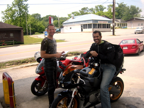
Figure 32. Joe and Stuart...Aprilia Futura and Buell XB12R!
(hey Joe I own a 2000 Aprilia Mille!) Morganton, Georgia.
Joe commented on
my "Mert Lawwill" shirt and wondered if Mert had autographed it (he had, of course). They
were really nice guys and Joe recommended that we ride "The Dragon". I had decided not to
do it (it's a little east of our route), but Joe said if possible we should. We left them
(we were going opposite directions) and crossed over into Tennessee. The riding became a
little less "intense" but still very enjoyable (TN 68). After a short while we arrived at
Coker Creek, TN, were we got a Tennessee map from the nice lady at the Welcome Center and
also some advice on finding lunch. She suggested we go a few miles north to Tellico Plains
which we did, and got a hamburger. However...Tellico Plains is the
junction where you turn
east to the Cherohala Skyway (Cherokee NF/Nantahala NF) which is said to be a simply
gorgeous with wide vistas and sweepers. I want to ride it!!
And it leads to the "Dragon"!!
Too many roads, not enough time!! I'd love to come back here and spend
more time...definitely in the future!!
Anyway...we bite the bullet (damn job!) and head west on TN 68 and US 70 through
Spring City, Crossville, Sparta, then TN 96 southwest to Murfreesboro, where we're spending
the night. There were not many curves, but very "mellow" country; not much traffic (55 mph
speed limits), and generally pretty country. I had one exciting moment when I pulled out
to pass a string of cars and a guy in a pickup pulling a trailer decided to turn left in
front of me! I hit the brakes and missed him no problem...what a dork! We did have a
couple showers, but fairly brief and no problem at all. Oh yeah, the first shower (which
didn't really continue) caused me to stop near a bridge over a river (don't know which).
It was just
beautiful (hey, any running water is beautiful to this New Mexican! ;-)
so I walked down to both the river shore and the bridge and took some pictures.
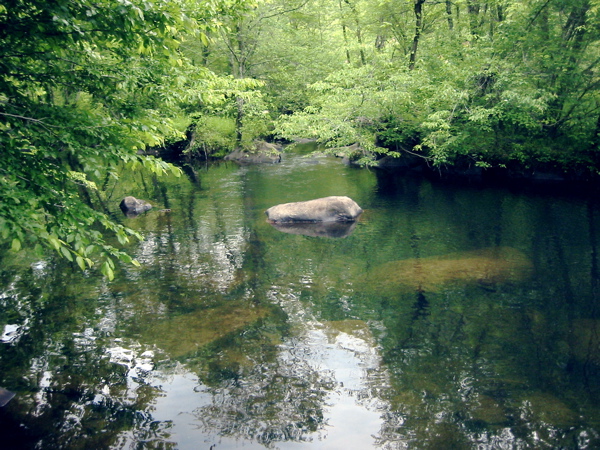
Figure 33. This river in Tennessee just had a primeval
feel to it...
this has gotta be "God's country."
The birds were singing, echoing through the forest; there was a real "primeval" feel to it.
Don't get that kind of country in the west at all. Murfreesboro is slightly southeast of
Nashville; there is still a LOT of Tennessee to cover! We'll presumably spend Sunday night
in Arkansas, and I'll switch over to the second part of the route home on the GPS. The
statistics for today's ride: Distance 278.4 miles, moving avg. 49.0 mph, overall
avg. 37.3 mph, max speed 77.0 mph, total time 7:28, moving time 5:41,
ending elevation 715 feet (getting a little lower again). Had dinner at "Shoney's"
restaurant; tried to get a smaller meal with a BLT, but it was HUGE. Ate half and kept the
second half for lunch tomorrow.
Before bedtime the
weather forecast (NWS broadcast on both TWC and my "weather radio") indicated a severe
thunderstorm about 20 miles south of Murfreesboro,
at a town called Shelbyville (we went
through there the next morning). It could have 60 mph winds,
quarter-sized hail, and dangerous
lightning. But where we were it was quite tranquil. So we went to bed around 10:00.
Day 10 (Sunday, May 21): Murfreesboro, TN to Mountain Home, AR...432 miles
At around 1:00 a.m. we were awakened by a SHHHHH sound...it was raining HARD!
And KA-BOOM...a
little lightning and thunder, too! We went back to sleep,
then I got up when the alarm
went off at 5:30 (groan), and looked out the door to find fairly cloudy conditions, but no
rain. Everything was very wet, of course (Figure 34).

Figure 34. After the hard rain that night we had a wet
morning greet us, but no rain (Murfreesboro, TN)
We walked to the nearby Waffle House (naturally) and had a
good breakfast, then started packing up. We got underway about 7:45. It seems to take
me about two hours from rising to leaving (just like at home). We headed south to the
aforementioned Shelbyville (no indication of any damage, however). We passed some big
horse ranches (Tennessee walking horses) that were really spiffy...mucho $$$.
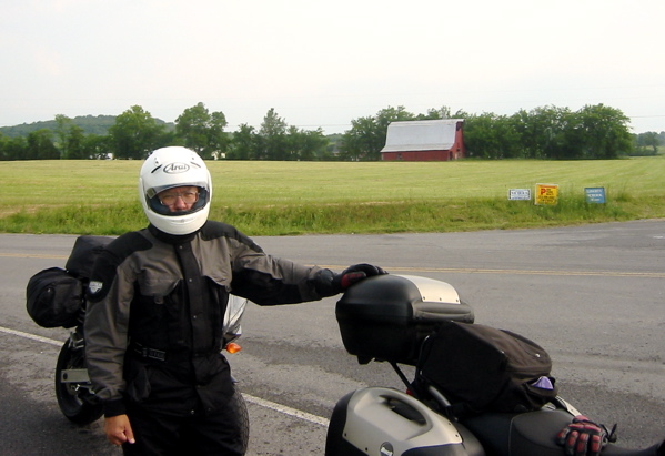
Figure 35. Lots of pretty horse ranches in Tennessee (TN walking horses);
this was a field from one of them...cool enough for ATGATT (finally!);
hey, the mesh jacket is pretty tough and quite well-armored, too...
We then turned
west on US 64 (hey, the very same US 64 that goes between Tres Piedras and Tierra Amarilla,
and is the best road in New Mexico). The
countryside was very "mellow" with green valleys, small towns (lots of Civil War references
and the odd Confederate Flag on display), and wooded ridges with some fun curves. Oh, and
LOTS of churches...the (northern) FL, GA, TN, etc. is not called the "Bible Belt" for
nothing. No problem as far as I was concerned...lots of witty church billboards and
marquees. I did get the impression (this WAS Sunday morning) that the churches were perhaps
"overbuilt" in terms of buildings/people. Perhaps attendance has dropped; most likely.
The good 'ol USA is rapidly becoming a "heathen nation" on par with L'Europe.
I guess we'll all find out someday...perhaps a motorcycle will hasten the process! NAH!!
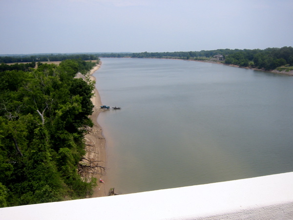
Figure 36. The "Mighty Tennessee" (river, that is...).
Pretty darn big by New Mexico standards!
We crossed the Tennessee River (Figure 36); it was quite large. I guess the TVA (Tennessee
Valley Authority) wouldn't exist if the Tennessee River weren't fairly substantial. One of my
colleagues at UNM (Univ of NM) back in late 70s quit to go to work for the TVA. Prolly retired
by now.
We continued
on US 64 through small TN towns (with not much going on; but still pretty well-kept). As
we approached Memphis the traffic (and nice houses, etc.) increased, as did the heat and
humidity! The traffic and road surface on the interstate highways in the heart of Memphis
were pretty bad (they pretty well sucked), but we got through.
There was absolutely nowhere to stop to get a picture
crossing the Mississippi River...a marked contrast to our outbound crossing at the Mississippi
Welcome Center (Vicksburg) where there was a very nice little park and facility.
That was an indication
of what eastern Arkansas ("land of opportunity") initially had to offer, I guess.
After crossing the Mississippi on I-40, we turned north on I-55 for 15 miles,
then turned northwest on AR 63 through northeast Arkansas.
What a depressing prospect! The elevation was about 200 feet, the temperature
(I saw a sign) was
92, the humidity was probably 80%...downright miserable. And the landscape was even more
depressing. Rice and soybean fields that were not green
(yet, I assume; maybe ever), and water that
WAS green. Evil-looking and evil-smelling acres of fetid green water! YUCK!!
I couldn't bear to stop---much less take any pictures.
After about
80 miles we stopped to check directions at Harrisburg, AR. It was muggy, yucky.
And to top it off when I put my foot down I stepped
in a BIG WAD OF GUM!! I was just miserable. Lord get me outta here! I can see why
Glen Campbell got out...hey, did "Slick Willie" ever get down here?
We continued on---what else to do?---and stopped for fuel at Newport, AR,
where the prospect was little better. NOTE: I know the Ozarks are coming up, and
I'm a little familiar with them---things will be getting better!
At the Newport gas station/convenience store the "handyman" was a short, stocky young man
who was up in the bed of a pickup bending over at some task...about 4" of butt crack
showing (hey, missed a great photo op)...then an obese lady got out of a monster
SUV with her fat breasts flopping around
(thinly disguised under a muu-muu thing). Everyone looked pretty dispirited, as did the
entire prospect. Fortunately we started gaining elevation fairly soon upon leaving, and
even 100 additional feet improved things! The road got a little curvy, there were more
trees, the homes had mowed yards, etc. ALL RIIGHT!
We continued to climb and the riding became more
fun. Finally at about 5:30 we arrived at our destination: Mountain View, Arkansas!!
A record
early arrival time!
The
day's statistics: distance 431.5 miles, moving avg. 57.4 mph, overall avg. 50.5 mph, total
time 8:32, moving time 7:31, max speed 85.0 mph (passing an SUV as usual),
ending elevation 873 feet.
We ended up stopping at a "Days Inn" in Mountain View with a nice room (more space than usual).
We'll probably eat at the Pizza Hut across the street, and I already
bought a Mountain Dew (seemed fitting) at the nearby convenience
store to pick me up a little (I was late in
taking my, um, "medication"; probably made the grim prospect even grimmer).
It had been a long, hot, humid
day of riding today; no alarm tomorrow morning.
But tomorrow looks like
nice riding through the Ozarks and Ouachitas; tomorrow night we should be in Oklahoma!
Oh yeah, one more thing:
when Dave walked out of the
room about 9:00 (I was in the shower) a van pulled up to the room next to ours and some guy
jumped out of the van and dashed into the room, slamming the door behind him (I heard it
shudder while in the shower). We thought "with the entire f***ing motel vacant, why did they have
to give him the room right next to ours!?" Turns out that he/they were quiet the whole
night, and there was nothing there in the morning; motorcycles were also fine. Go figure.
One final thing: there is roadkill all over the place...raccoons, turtles,
armadillos, etc.
Yesterday I saw a little turtle which had made it almost all the way across; hope the little
guy made it!
Day 11 (Monday, May 22): Mountain Home, AR to McAlester, OK...340 miles
Ahh..caught up on sleep! Slept until almost 8:00 a.m.!! Just what I
needed. Looks cloudy outside; forecast is for slight chance of thundershowers. From TWC it
looks like we're headed just outside the main region of showers, so I doubt if we'll see too
much bad weather. I shortened the route slightly so we miss some of the Ozarks. Dammit!
Just like the Great Smokies---we ride 1500 miles to get to a great area, then to keep
on our blasted schedule we have to MISS most of the great riding to get
home in time!! ARRGGHH!
Don't pay too much attention to me; it's just that I have to get back to this country and
devote 3-4 days to the Great Smoky Mountains and 2-3 days to the Ozarks. Maybe more.
Hmmmm, fourth son Jeff just turned 13; in three years get him a Wee-Strom and head back?
No, not soon enough. Family vacation back east? Ulysses rally in NE Tennessee like Chad
wants to do? YOU BETCHA!!
Anyway, our next three days have to add up to 1005 miles. I figure we'll
stay in McAlester, OK tonight, Amarillo, TX Tuesday night, then Wednesday we're home! We'll
see. In a few minutes we'll got to the motel breakfast buffet; I'm not expecting much since
we're almost the only guests (I was right).
Now on to the riding: Upon reflection I think that today was perhaps the best
day riding of the entire trip! We left Mountain View on AR 9
in somewhat foggy conditions...I would
have liked to get a picture, but by the time we found a place to stop the fog had pretty
much burned off. That's what we get for starting late (about 9:45 a.m.)
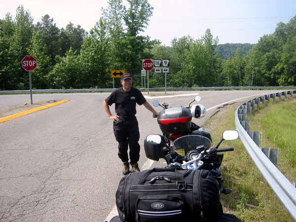
Figure 37. No matter which way you go in the Arkansas Ozarks the riding is great!
About the only problem is Clero Mullins pulling his tractor across the road as you
round a corner. This
is the junction of AR 9 & 16 near Rushing, AR.
The riding in
the Ozarks was simply amazing! IMHO it was the equal of the GA/TN/NC area, with the bonus
that there was almost NO TRAFFIC! Probably the biggest hazard was local farmer
Clero Mullins (a real Ozark farmer, BTW)
driving his tractor out his driveway as you come around a corner!

Figure 38. Instead of "winding road"...in the Ozarks it's "crooked and steep"...
and (thankfully) they are! One of many such signs we saw that day.
But we had no such
problems. It was like riding a rollercoaster...up, down, left, right, everything! The
roads were pretty technical with lots of elevation change. Road surface was usually quite
good, and the Ulysses sure was the bike to have! Pure fun! Elevation varied from 800 to
about 1800 feet. The drop down off the Ozark Plateau was quick and decisive! You could
feel the heat and humidity increase as you dropped down...kind of discouraging ;-) The
Ozark "winding road" signs are humorous: they say "crooked and steep"...and they are
(see Figure 38).
After dropping off the Ozark Plateau we
crossed I-40 at Russellville, where we refueled and had lunch (Waffle House!). Back
to heat and humidity (elevation 200 feet again).
Now...I had
some idea of what the Ozarks were like, but I had NO IDEA what the Ouachita Mts. would be
like. It took a little while to get to them, but they reminded me a little of New Mexico;
more wide open with wider sweepers.
I first heard of the "Talimena Parkway" back when I was NM State Director of the Honda
Sport Touring Association (but rode a Ducati). They have a rally there every year. Dave
also knew of it; his dad had taken him over it back in the 90s...
It took a little searching, but we finally found
on a "lateral" up to the Talimena Parkway (which actually started at Mena, AR, which we
bypassed).
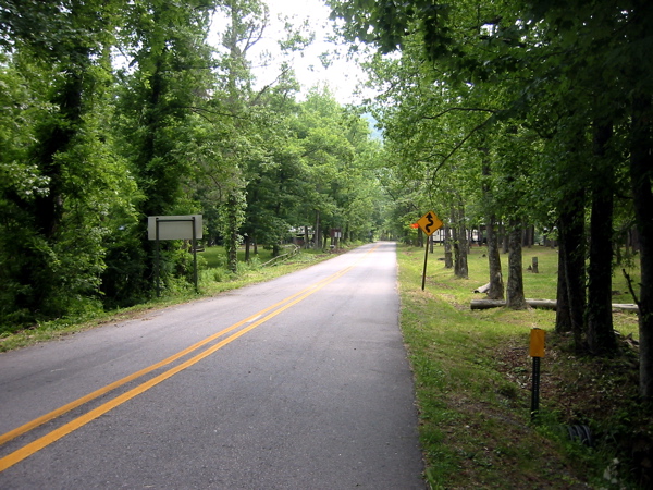
Figure 39. This delightfully twisty lateral got us up
to the legendary "Talimena Parkway"
But our little lateral (Figure 39) was great fun! And when Dave had walked into the little
store to ask for directions to the Talimena Parkway
he found the old guys more interested in their checker game than
dealing with him! He said it was like a time warp. Pretty funny. Anyway, the Talimena
Parkway is amazing. It follows the top of a ridge with many viewpoints, like the
one in Figure 40.
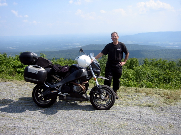
Figure 40. Our first viewpoint on the "Talimena Parkway;"
in the Ouachita NF on the AR/OK border.
Lots of curves,
and pretty good road surface. I can see why the HSTA guys have rallies there. There were
even some backpacking trailheads along the route (within the Ouachita NF). Reminiscent of
Woody Gap on the Appalachian Trail. The highest elevation on the Talimena Parkway was over
2500 feet! And the temperature was notably cooler...very nice!
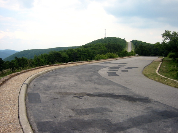
Figure 41. The road pretty much follows the ridgeline (picture taken
from a pullout; road surface is better than that!)
You can see the notches in the ridges where the road goes through (Figure 42).
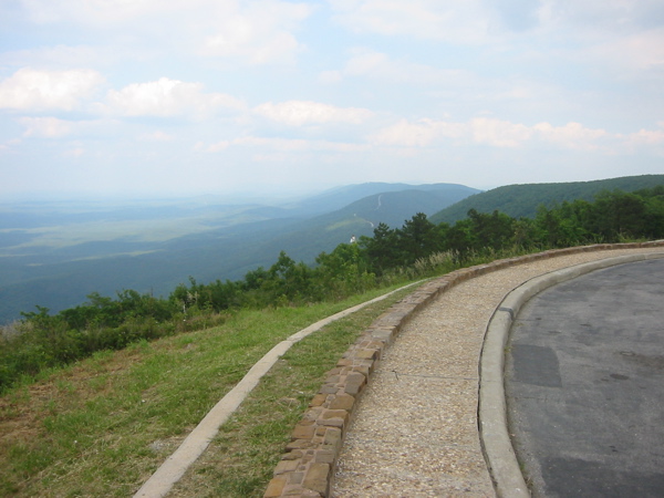
Figure 42. There's a notch in every ridge where the road
is cut through (hard to see here, but trust me!).

Figure 43. There goes the Talimena Parkway, winding up to the
top of yet another hill! Tough road on a pushbike!
We finally descended from the ridge and had a 50-mile
ride into our overnight destination of McAlester, OK (the AR-OK state line was on the
Talimena Parkway). The Parkway actually ends at Talihina, OK, where we finally found a
convenience store/gas station to refuel (we were both pretty low). The ride into McAlester
was uneventful (a couple curvy areas) but the sun was in my eyes and I was pretty tired
(hell, I had already ridden almost 300 miles over very twisty roads in some
pretty warm weather ;-)
Anyway, we seemed to get through McAlester without finding any motels (I knew there
were plenty of motels there from MapSource that evening before). So I punched up the Super
8 on the GPS and it led us back and south. But the Super 8 had no restaurant nearby. So
I punched up the Days Inn (it was nearby) but they had no rooms (some conference). But
there was a Best Western right next to it, and they had two "smoking" rooms w/queen beds. So
we took them, not wanting to spend the next hour looking for rooms (it was pretty hot and
humid enough for me). The reason there were no rooms is that a bunch of "oil drillers" had
descended on the place. So I guess Oklahoma is still producing oil.
There was even a restaurant nearby. Perfect. And the rooms are quite
nice. And there was even a POOL; in pretty good shape, so Dr. Greg hit it ASAP, as
shown in Figure 44.

Figure 44. If there's a decent swimmin' hole nearby, Dr. Greg is in it!
The day's statistics: distance 339.8 miles, overall avg 47.6 mph, moving avg 54.9
mph, max speed 86.3 mph, total time 7:08, moving time 6:11, ending elevation 872 feet. There
was even a pretty sunset which I tried to capture in Figure 45.
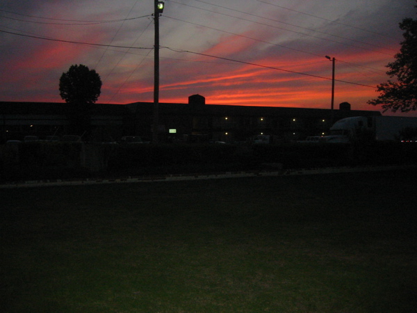
Figure 45. Pretty sunset at McAlester, Oklahoma.
I knew I recalled McAlester, Oklahoma from somewhere...it's in John Steinbeck's
book "The Grapes of Wrath"...the book starts with protagonist Tom Joad recently released
from the state prison in McAlester, Oklahoma. Well, the prison's still there.
Day 12 (Tuesday, May 23):McAlester, OK to Amarillo, TX...387 miles
Had a little trouble getting to sleep last night, but slept well once
asleep. Awoke and did the "body scan" meditation, then met Dave for breakfast at 8:00 a.m.
(remember, we had separate rooms; maybe that's why I didn't sleep as well).
The restaurant next to the motel was definitely a "good ol' boy" gathering point---my
kind of place!
The waitress at the restaurant was a young lady who was,
um, very efficient, and you felt like you better have your
order ready when she came around or you were wasting
her time. That's OK; she was very nice. Good breakfast, too (usually true at these
"good ol' boy" places).
We left around 9:45 a.m. (remember, it always takes me two hours) and
the heat felt really intense! Once we started moving I felt a lot better, and during the
day I never really felt that hot (well, not until the end). After leaving McAlester we
stayed on secondary roads heading generally west across southern Oklahoma. In
particular, US 270 to Ada, OK 19 and 29 to Lawton, OK then US 62 into Texas. Anything
to avoid the interstates!
The country was
still fairly green, but less so as the day progressed. There was a stiff wind from the
south, so it was generally coming from the left. The hot air from the engine on the Ulysses
was blowing right across my lower right leg, and---when exacerbated by the wind---made my
leg so hot I had to put my toes on the footpeg; not a problem (I sometimes ride
like that by choice)
but at the end of the day I
had a red mark on my calf to prove it! The GPS got me turned around a couple times when
going through the small towns, but we figured it out. I was going to stop and take a photo
of a sign in "Pauls Valley" (my oldest son is named Paul) but didn't.
I don't think Paul would care.
We crossed into
Texas right after going through Hollis, OK on US 62;
things are somewhat "junkier" than we saw in,
say, Georgia or Tennessee. In addition to the wind, the temperature was quite hot.
When we
arrived at Amarillo it was 95 degrees (and 6 percent humidity!).
I took a photo (Figure 46) where we
stopped to rest at the junction of US 62 and TX 256, about 15 miles before
Memphis, TX (thankfully not Memphis, TN!!).
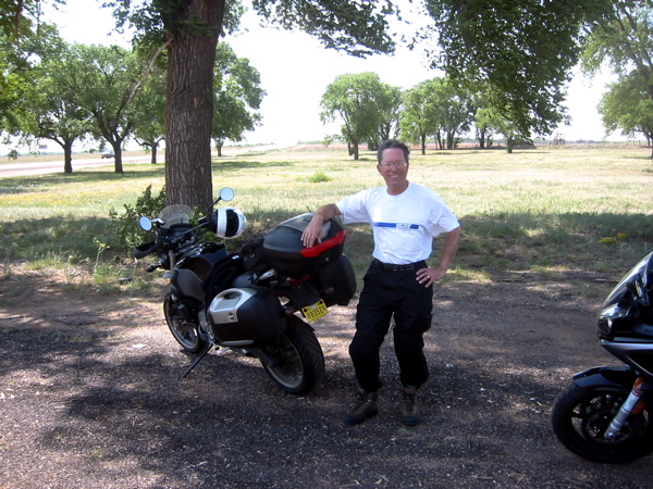
Figure 46. At the junction of US 62 and TX 256, near Memphis, TX. Kind of a
junky place to rest, but infinitely better than Memphis, TN! Note the wind
blowing Dr. Greg's hair back...the winds were never really a problem
on the Ulysses---thank you Laminar Lip!
At Memphis we joined hwy 287 which turned north slightly, thereby gaining
us a little bit of a tailwind, which was greatly appreciated. We hightailed it into
Amarillo, and I took the first motel I found.
Note that ONLY reason I went to Amarillo (which is on I-40) is to find some
motels...the interstates absolutely SUCK SUCK SUCK!!
It had been a pretty long day, and the last
bit was hot and tiring.
We easily found a motel on the east side of Amarillo, TX (on I-40); in fact there was a
nearby ubiquitous "Waffle House" where we ate dinner and will probably
eat breakfast there as well. The day's statistics: distance 387.3 miles, overall avg 55.6
mph, moving avg 61.5 mph, max speed 90.2 (frustration after a construction zone), total time
6:57, moving time 6:17, ending elevation 3656 feet.
Our motel was right next to a truck stop (Figure 47),
but it was a new motel and very well insulated, so no problem with noise.

Figure 47. The view out our motel room at Amarillo, TX. Note that flag;
we're looking north, so there's a brisk west wind (typical in these parts).
Although it was 95 degrees, the humidity was 6 percent!! (again typical).
At 8:19 p.m. it is still very light out...that's because
we're on the very western end of
the Central time zone. Consider this: we have been on Central time
from when we entered eastern
Tennessee. We have been in Central time for 1060 (straight line) miles!! We won't change
to Mountain time until tomorrow when we enter New Mexico. Seems like a long time.
Maybe it's just me...
Day 13 (Wednesday, May 24):Amarillo, TX to Albuquerque, NM (HOME!)...339 miles
Fell asleep very quickly last night...what a relief! Slept well until
about 5:00, then until 6:45 when the iPod alarm sounded.
Even though we were located right next
to a busy truck stop (Figure 47) there was almost no noise from the trucks.
Weather looks clear with a brisk breeze
from the west. This will be the last morning to pack everything up, then we're home!
The first thing we'll do is turn south to avoid I-40!! Specifically I-27 south to US 60 to
Farwell, TX, then west on US 60/84 through Clovis (also on our outbound route), but we'll
continue on 60 through Ft. Sumner to Yeso, Vaughn, Encino, NM; finally north to Clines
Corners on I-40, then back to Albuquerque on the (yuck) interstate. The
secondary roads will require an additional 40 miles (compared to I-40) but the quality of
riding is much better. On a motorcycle interstates pretty much suck...like I said.
It was my last chance to have breakfast at the "Waffle House" so I did in fact get the "All
Star" breakfast (includes a waffle). Too much food, but really good!
Also a very attentive
waitress. The wind is supposed to change to be somewhat NNE at 10-20 mph, but right now it
looks like it's from the west. That's OK, winds don't bother us that much.
Like I said earlier, the plan is
to head into Amarillo, then south on I-27 to Canyon, TX (home of Mandi Moore...star
UNM women's basketball player---I have season tickets), then
southwest to Hereford ("Beef Capital of the World"), then into New Mexico at Clovis. We
stopped at the New Mexico Welcome Center just before Clovis---this time we didn't need a
map---but it was a pretty nice facility. Got a picture of me outside to celebrate our
return to New Mexico.
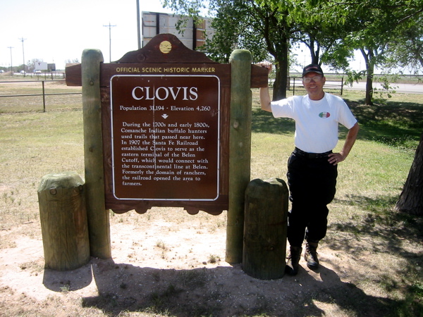
Figure 48. Hey, we're back in New Mexico! Specifically, Clovis, NM on US 60/84.
The riding conditions were excellent; the wind had in fact changed and was
actually somewhat of a tailwind. You know, the winds were just not a problem anywhere on
this trip. I guess the "Laminar Lip" really works! On through Clovis and Cannon AFB (still
apparently saved from closure), to Ft. Sumner. The route from Clovis to Ft. Sumner
was the same as the outbound trip. At Ft. Sumner we continued west through the "towns" of
Yeso (only a Post Office), Vaughn, and Encino (only a gas station/convenience store at
both). There were---as was the case at many small towns we saw---lots of "boarded up"
motels and cafes. Kind of sad. The interstates have really killed the small towns.
Damned interstates.
It was past lunchtime, but we had to continue up US 285 to meet I-40 at Clines
Corners before we had lunch. The gas station/Subway where we ate had a "Remember Then"
leaflet for 1953 at the table (The "Billy the Kid" museum in Ft. Sumner had a bunch of those
on our outbound leg...should have bought the one for 1947; my birth year).
Anyway, the 1953 "Remember Then" was pretty interesting.
The price of gas is relatively about the same now as then. There was an ad for a McCulloch
chainsaw for $225!! Since the average rent then was $83/month, that's almost three months
rent! You can probably buy a chainsaw now (made in China, of course)
for way less than $225 in 2006
dollars. Amazing. But having a (20-pound) chainsaw in 1953 was probably really cool!
The
highways had been wide-open, 70-mph speed limit (so I rode around 75-80 mph
as indicated on GPS). I just don't find riding fast in a straight line much fun. We
arrived at Dave's house (about 15 miles east of Albuquerque)
about 3:45 p.m. and took a picture of us both (Figure 49) to celebrate the end
of our epic ride. He clipped a beautiful bouquet of roses for Annie (it's on the table in
a vase right in front of me as I type this). What a great guy...he's my best friend!
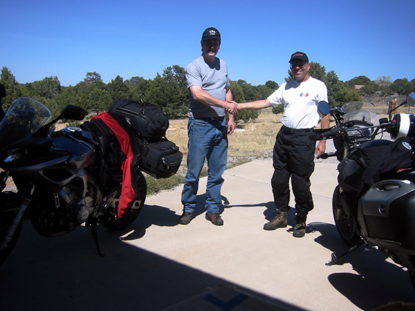
Figure 49. A final handshake! David Wilson and "Dr. Greg" at David's house in
Sedillo, NM. My former student, best friend, and riding buddy. Good job, mate!
The last 15 miles into Albuquerque were
uneventful, and I arrived about 4:30 or so. The last picture of the trip (Figure 50)
shows me hugging my
wonderful wife Annie, whom I thought about every mile of this trip.

Figure 50. My wonderful wife Annie...I'm home!
The days' statistics:
distance 338.8 miles, overall avg 59.6 mph, moving avg 65.9 mph, max speed 91.2 mph, total
time 5:41, moving time 5:08, ending elevation 5040 feet. Total mileage for return leg of
the trip: 2271 miles. Total mileage for the trip: 4072 miles! I'm home.
Epilogue
This was a wonderful trip---everything worked beautifully. The Ulysses was the
perfect bike for a ride like this; it
probably used a quart of oil in 4100 miles.
The Laminar Lip offered just enough protection
from the wind. The Avon AV45/46 tires were wonderful...lots of wear left (rear will go
10,000 miles, I'm sure) and excellent handling characteristics. I wish I had an extra
week to spend in the Great Smoky Mountains, and another 3-4 days to spend in the Arkansas
Ozarks. Next year?